Public Hearing Preparation:
- Plan to speak at the November 14, 2022 Planning Commission Public Hearing
- Use the online Citizen Comments page here: Cluster Subdivision/Prime Ag Soils Citizen’s Comments.
-
-
- Scroll down to the “citizen comment box” to make specific, detailed comments.
-
-
- Email comments to the Planning Commission at LoudounPC@loudoun.gov with “cc” to DPZ@loudoun.gov, and BOS@loudoun.gov.
Best “Cliff Notes” summary:
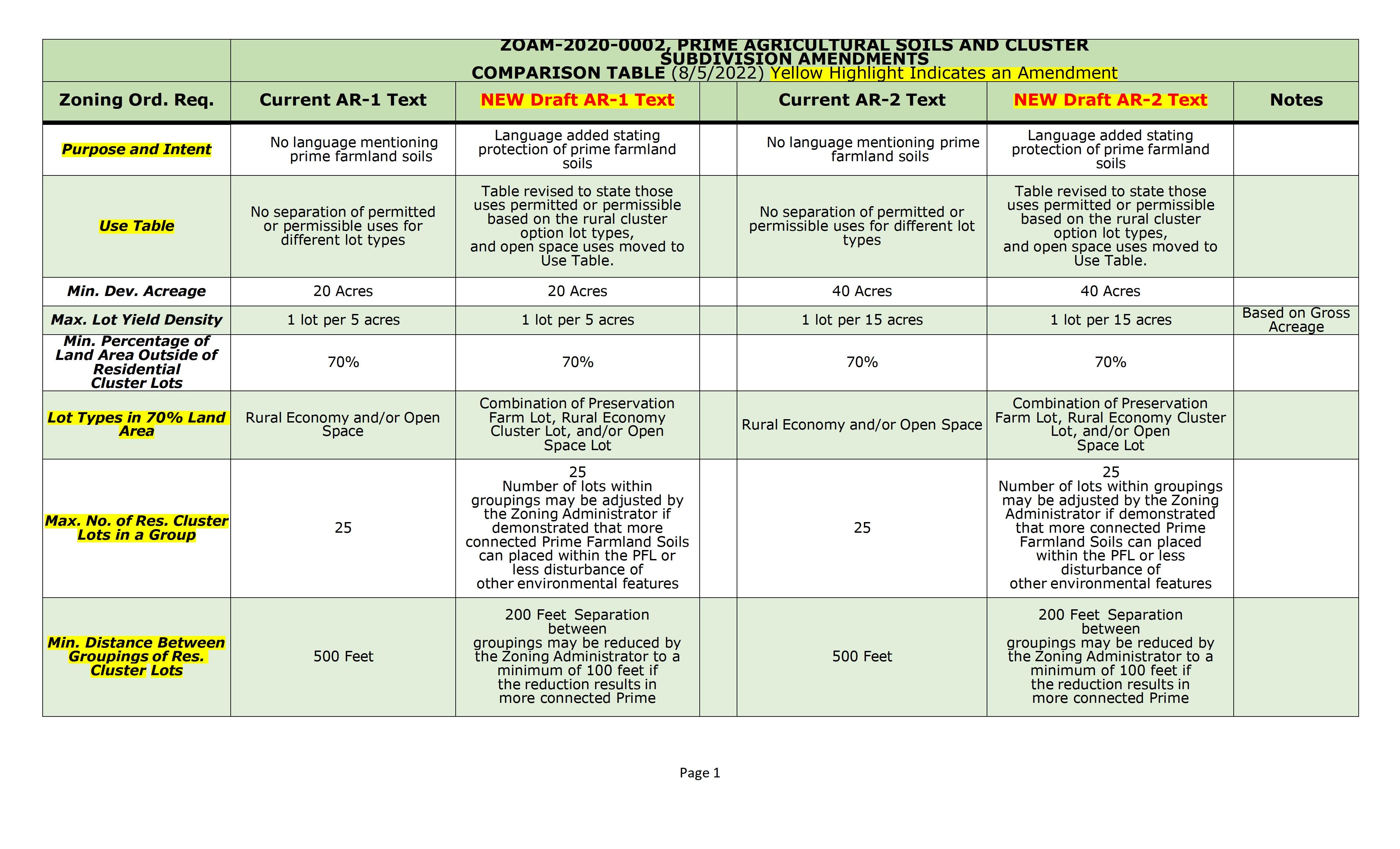
2022_10-25- ZOAM Draft Text Comparison Table-REVISED
ZOAM-2020-0002-Draft-Text-Comparison-Table-080522
DOCUMENTS & INPUT
ZOAM-2020-0002 Referral Cover Memorandum 080822
2nd Draft Text Article 8 080522
2nd Draft Text – Article 2 080522
ZOC Comments-Responses -2nd Draft 080822
Outreach Group Input Comments – Responses-2nd Draft 080822
2022_08-08-Prime Soils-Cluster ZOAM 2ndDRAFT-TEXT-INPUT
12-01-2021 ZOC PACKET – ZOAM-2020-0002
2022_01-03-ZOAM-2020-0002 DRAFT TEXT REFERRAL
02-16-2022 ZOC Packet-ZOAM
ZOAM-2020-0002-INPUT-ZOC-03-2021
2022_01-13-ZOAM-2020-0002 Questions to Staff
Frequently Asked Questions |
ZOAM-2020-0002 |
| What is ZOAM-2020-0002?
|
ZOAM-2020-0002 is the Prime Agricultural Soils and Cluster Subdivision Zoning Ordinance Amendment. This ZOAM began with the realization in August 2019 that the current cluster subdivision regulations were out of synch with the June 2019 adoption of the Comprehensive Plan.
To address this inconsistency the Board of Supervisors initiated a zoning amendment in June 2020. A series of stakeholder meetings have been conducted by County Staff, and the second draft text document is currently in review. |
| Longer version: – What is a “cluster?” – Why the focus on “prime ag soils?” – Can prime soils used for clusters revert back to farmland? |
|
| What is “cluster?” | A “cluster” is a grouping of houses developed on smaller lots on a portion (e.g., 30%) of a larger parcel of land. The intent is that the remaining land (e.g., 70%) would be used/dedicated to agricultural, equine, open space, trails and rural economy uses.
The Code of Virginia requires a county to provide “clusters,” (but does not require “bonus” density). The 2019 Comp Plan Rural Residential policies call for clusters to provide “limited development to protect land for agricultural operations, rural economy, equine uses, passive recreation, open space uses; minimize traffic impacts and reduce demand for additional public facilities and services” (Ch. 2, Rural Res. Policy 2, Strategy 2.1). |
| Why the focus on “prime ag soils?” | “Prime soils” are those soils that provide the best potential for economically viable farming (crops and livestock) to enable Loudoun County to retain its areas of agricultural production for our county’s and region’s long-term food security.
Prime soils are also the preferred soils for septic/sewage systems in cluster subdivision lots. Clusters and other development over the past decades have been built on large portions of Loudoun’s prime soils, (with an estimated loss of 67 sq.mi. of farmland* between 2002 and 2017). * American Farmland Trust / SRL estimate. |
| Can prime soil used for “clusters” revert back to farmland? |
Once soils have been used for waste they cannot be converted back to farmable land. |
| I live in the western part of the county: What does the Cluster Subdivision/Prime Ag Soil ZOAM-2020-0002 have to do with me, my neighbors or HOA? I live in the eastern part of the county: |
This ZOAM impacts ALL County residents in two primary ways:
1. The ZOAM is intended to implement the 2019 Comp Plan policies to maintain the rural areas of Loudoun according to the County’s vision as a sustainable community for residents who live there, those who work there (in both rural ag/farming or other work) and for those who play there at any of the many rural tourism venues, and 2. By managing total growth and related impacts to all county resident’s local tax bill, and county-wide traffic. Below expands on this second point. |
| How do clusters relate to county “build-out?” | In July 2021 County Staff provided the Transportation Land Use Committee (TLUC) key assumptions indicating that the 2019 Comp Plan quantity of “11,896” remaining potential by-right houses in the Rural Policy Area (RPA):
– “assumes build-out of the RPA” (i.e., when the county has been developed to the maximum extent allowable by law) for the Rural Policy Area, and Therefore, the regulations for and the development of clusters has a direct impact on the timing of “build out” of the county (i.e., the point when Loudoun County looks similar to other counties to the east). |
| Longer version: – What is the maximum Loudoun may see in the future? – I’m visual – are there any maps to go with that? – What impact does it have on my future tax bill? – Are there any numbers to go with that? |
|
| Is the 11K build out in the west the maximum Loudoun could see in the future? |
No. County Staff in 2021 also confirmed that the anticipated “build-out” did not include parcels under common ownership that can be (and are being) recombined to apply for cluster subdivisions.
Per County P&Z Staff (2/11/2022), there are ~120 20+ and 40+ acre parcels that “once combined” would be approximately 25,000 additional “clusterable” acres. Modeling using the current cluster regulations, this could equate to an estimated 2500 additional homes or more, not reflected in the 2019 build out $11K assumptions. |
| I’m a visual person – are there any maps you can point me to? |
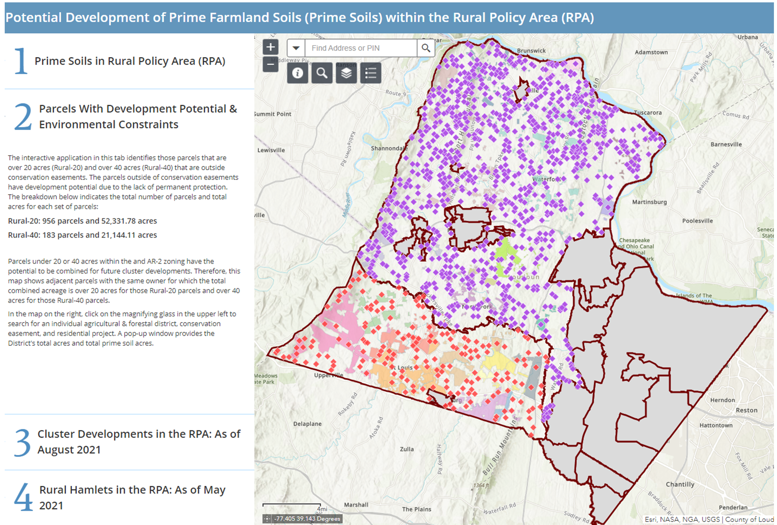
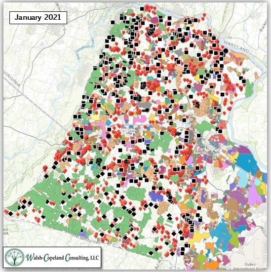
Sure. Using county data and GIS mapping in Jan. 2021 I mapped the 20+, 40+ and re-combinable parcels under common ownership. In Oct. 2021 the County Mapping Department analyzed the same data and their maps produced the same end-state view as I found in early 2021.
Go here to view Staff’s “Potential Development of Prime Farmland Soils within the Rural Policy Area (RPA)” (Also see map snapshot at the end of this post.) TIP: Map #2 shows all parcels outside of conservation easements that have development potential to become clusters, including those under same ownership that can be recombined and clustered. It is a map view of potential “build out” of Loudoun County. Go here to see the year-by-year building permit applications. (TIP: click on Policy Area tab then Rural to see only western cluster and by-right building permits) |
| What impact may it have on my future tax bill? |
County Staff in 2019 estimated build-out of Loudoun in the range of 11,000 by-right and clustered units.
– Adding: the potential quantity of houses that may result from clustering parcel recombined under common ownership (estimated based on County information to be in excess of 2500 additional units). Impacts of all new homes include: – Every new home produces an estimated 10 car trips/day |
| Are there any numbers to go with that? |
Here’s where I’ll rely on studies from experts.
The County’s Comp Plan consultants* reviewed several past studies. – A Nov. 2007 study calculated the cost of residential land use to be $1.62 for every $1.00 of tax revenue received. – A different study done May 2015 concluded the “housing in Loudoun County costs $1.20 in services for every $1.00 in revenue. – However, County consultants in 2018 pointed out that the 2015 study only used operating expenses for county services (i.e., the study did not include the cost of building schools, fire houses, libraries, parks, roads, etc.). Capital costs should have been applied as development in the rural area does not contribute to (proffer) capital costs. (*TischlerBise 8/8/2018 review of RCLCO, “The Cost of Housing in Loudoun County,” p. 9-12) The American Farmland Trust (AFT) has performed Cost of Community Services (COGS) studies in 30+ states and found, on average, the median cost for residential land was $1.16 for every $1.00 in taxes received, and for open space land and working farms was $0.37 for every $1.00. They confirmed that open space lands generate less revenue than residential, but they also require less capital public infrastructure and fewer community services (schools, social services, health, fire safety, police, etc.). A Fauquier County COGS study obtained similar results, finding $1.17 for residential land use and $0.22 for agriculture/open space land use. These results are in line with the $1.20 results using operating costs only. |
| Can you net out WHY there is less impact to my tax bill for agricultural uses, open space, and forest / mountainside? | Sure — Because horses, cows, corn, and trees don’t drive, go to school or need the same county services. |
| Will this ZOAM “fix” the Comp Plan inconsistencies and other issues from the current Zoning Ordinance? | It’s too soon to tell, because there are still a significant number of details being debated for the ZOAM. Staff is trying to balance:
– Impacts to Prime soils, loss of farmland and open space; Also key will be whether the new cluster ordinance will apply similar regulations as the grandfathered Rural Hamlet option where open space and conservancy (agricultural) lots were placed in permanent open space easements. If the agricultural and open space cluster lots are not placed in permanent easement in the new zoning ordinance then a future Board of Supervisors could change the zoning to allow further subdivision with a vote of five Supervisors. |
| I’ve heard that some have said this ZOAM should just be scrapped and leave prime soils/farmland protection to conservation easements. Are conservation easements the best option to protect rural Loudoun? |
From the standpoint of permanence, yes. From the standpoint of impacts, maybe, depending on the conservation easement type, terms and conditions, monitoring, and enforcement. |
| Longer version: What are the differences in conservation easement types, permanence, terms and conditions, stewardship and enforcement? |
|
| Types | First, there are two primary types: private conservation easements and county-held development easement. |
| Permanence | Private donations of conservation easements granted in perpetuity are the most permanent way to protect any land, including farmland and prime soils.
County-held development easements (typically managed by an HOA) may be modifiable by vote of the Board of Supervisors. |
| Voluntary | Private conservation easements are voluntary and therefore there is no way to predict the amount of land to be protected over time.
In recent years there have been philanthropic benefactors who have purchased land and put it into easement, also a voluntary effort. |
| Terms & Conditions | Easements differ in terms and conditions, monitoring and enforcement. Some private easement holders permit more high-intensity uses (e.g., event centers, agritainment, tourism, craft beverage manufacturing) on the land than others, which may impact the overall protection of the land and rural character. |
| Stewardship & Enforcement | Easement protections are only as good as their monitoring and enforcement. Private easement holders and county-held development easements differ in the frequency and level of monitoring for compliance and overall enforcement of the original terms and conditions. |
| Is this ZOAM part of the Zoning Ordinance Rewrite (ZOR)? | Like other ZOAMs, this is being worked in parallel with the Zoning Ordinance Rewrite, to be merged when completed.
The estimated completion (as of 2/16/22) is October, 2022, so there is time for additional public input. |
| (Although this was already a lot) where can I find out more about this ZOAM? | You can 1. Review the ZOAM draft text here2. Additional background (2019-2021) can be found here |
| Is there a direct link to provide Citizen Comments for this ZOAM before general public input hearings? | Yes. You can access the online Citizen Comments page here: Cluster Subdivision/Prime Ag Soils Citizen’s Comments |
| I missed the ZOAM-2020-0002 Prime Soil / Cluster Subdivision at ZOC on Feb. 16th. Any summary? | ZOC discussed the draft text as well as all Staff and stakeholder input to date at the Feb. 16th meeting. The recording for the meeting can be found here. |
Potential Development of Prime Farmland Soils within the Rural Policy Area (RPA)
Source: Loudoun Mapping GeoHub story map application
Potential Development of Prime Farmland Soils within the Rural Policy Area (RPA)
Easements, Clusters, 20+/40+ Vacant & Recombined Parcels with Existing Residential Communities
Source: Walsh-Copeland Consulting using Loudoun Mapping GeoHub data
Back to other Frequently Asked Questions page
Leave a Reply
Your email is safe with us.